

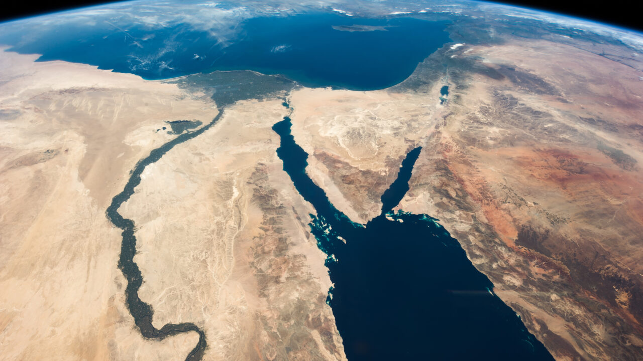
Egypt is one of the few countries on Earth that is genuinely transcontinental. The Suez Canal, the 193-kilometre waterway connecting the Mediterranean to the Red Sea, represents a continental boundary, meaning that standing at its edge, you can look west into Africa and east into Asia. That small triangular wedge of land to the east, the Sinai Peninsula, constitutes roughly 6% of Egypt’s total territory. The other 94%, including Cairo and the entire Nile Valley, is African. Yet the question ‘Is Egypt in Africa?’ remains one of the most surprisingly common questions in popular geography — one that sounds simple until you begin answering it properly.
Geography and identity don’t always coincide, and Egypt is perhaps the world’s most compelling example of that truth. Its position is not merely a matter of cartographic placement, but a case study in how geography, culture, language, religion and political history can pull a country in multiple directions at once, producing an identity that resists any single category.
When the Suez Canal was built in 1869, it didn’t only transform global shipping; it drew a hard line through land that had previously connected Africa and Asia, formalising a boundary that had been conceptually blurry for millennia. Egypt didn’t acquire a split identity in 1869 — but the canal made that identity cartographically explicit in a way that has shaped perception ever since. By any objective measure, the case is straightforward: the overwhelming majority of Egypt’s territory, its population, its capital and its entire historical heartland sit on African soil. But perception is not always governed by objective measures, and this is precisely where the interesting questions begin.
The confusion arises not from geography but from cultural, linguistic and political factors that are, collectively, quite powerful. Begin with language. Because of Egypt’s historical dominance in film, music and broadcast media throughout the twentieth century, Egyptian Arabic became the most widely understood dialect across the Arabic-speaking world — a Moroccan and a Kuwaiti who cannot understand each other’s local dialects can almost certainly both understand an Egyptian speaker.
Then there is the visual problem. Most observers carry a mental image of Africa built from sub-Saharan landscapes: savannah, red earth, equatorial forest. Egypt offers golden desert, monumental stone temples, and urban environments — Cairo above all — that feel far more akin to Beirut or Amman than to Nairobi or Lagos. The geography is correct; the aesthetic simply doesn’t match the mental category.
Egypt’s political history entrenches this perception further. Under Gamal Abdel Nasser in the 1950s and 1960s, Egypt became the defining voice of Pan-Arabism, hosting the Arab League and setting the ideological agenda for a generation of regional leaders. When he nationalised the Suez Canal in 1956, he became a symbol of Arab self-determination whose resonance extended far beyond Egypt’s borders.
In 1979, Egypt became the first Arab country to sign a peace treaty with Israel, a move so controversial it earned suspension from the Arab League for a decade. Since then Egypt has contributed troops to the Gulf War coalition, shaped the Oslo Accords process, and remained central to Gaza ceasefire negotiations and back-channel diplomacy across the region. For a country located in Africa, its footprint in Middle Eastern geopolitics is extraordinary.
Although Egypt was a founding member of the Organisation of African Unity (OAU) in 1963, its relationship with African identity has never been uncomplicated. Many Egyptians identify more immediately with Arab or Mediterranean culture than with any pan-African sense of belonging. The Sahara is central to understanding why. More than just the world’s largest hot desert, it has historically functioned as something closer to a cultural ocean — dividing the Mediterranean-facing civilisations of North Africa from the societies to its south, producing different languages, different trade networks and different historical trajectories on either side. Morocco, Tunisia, Algeria and Libya have all occupied the same ambiguous position as Egypt: geographically African, but shaped by forces that look northward and eastward rather than south.
Beneath all of this lies a more fundamental factor: Egypt is simply very old. The civilisation that built the pyramids and developed one of the earliest writing systems predates not just the Arab League and the African Union, but the very concepts of “Middle East” and “Africa” as we now use them. Each successive empire deposited something onto what was already there — Persian, Greek and Roman conquest; the Arab invasion of the seventh century that brought Islam and Arabic; Ottoman rule; British colonial administration. Modern Egypt is the accumulated product of all of it, and the attempt to fit it into any single contemporary category necessarily involves erasing most of that history.
The question “is Egypt in Africa”? has a clean answer: yes, geographically, unambiguously. What makes it distinctive is that it has multiple identities, but they are not in conflict — they coexist, operating simultaneously at different registers. Geographers sometimes reach for the concept of a “pivot state” to describe countries whose location gives them influence across multiple regions at once. Egypt is African by geography, Arab by language and culture, Middle Eastern by political history and Mediterranean by ancient heritage.